Our Changing Earth:
The lithosphere is broken into a number of plates known as the Lithospheric plates. You will be surprised to know that these plates move around very slowly – just a few millimetres each year. This is because of the movement of the molten magma inside the earth. The molten magma inside the earth moves in a circular manner as shown in the activity.
The movement of these plates causes changes on the surface of the earth. The earth movements are divided on the basis of the forces which cause them. The forces which act in the interior of the earth are called as Endogenic forces and the forces that work on the surface of the earth are called as Exogenic forces (Fig. 3.1) Endogenic forces sometimes produce sudden movements and at the other times produce slow movements. Sudden movements like earthquakes and volcanoes cause mass destruction over the surface of the earth.
A volcano is a vent (opening) in the earth’s crust through which molten material erupts suddenly (Fig. 3.2) Similarly, when the Lithospheric plates move, the surface of the earth vibrates. The vibrations can travel all round the earth. These vibrations are called earthquakes (Fig. 3.3). The place in the crust where the movement starts is called the focus. The place on the surface above the focus is called the epicentre. Vibrations travel outwards from the epicentre as waves.
Greatest damage is usually closest to the epicentre and the strength of the earthquake decreases away from the centre. Although earthquakes cannot be predicted, the impact can certainly be minimised if we are prepared before-hand. Some common earthquake prediction methods adopted locally by people include studying animal behaviour; fish in the ponds get agitated, snakes come to the surface.


Please Visit: www.ictfoundationindia.org
Points To Remember:
- The earth’s crust consists of several large and small plates which carry continents and the ocean floor.
- There are three types of earth quake waves: longitudinal waves, transverse waves and surface waves.
- Seismograph is the machine through which earth quake is measured.
- The magnitude of the earth quake is measured on Richter scale.
- The highest water fall is Angel Fall is in South America.
- The landscape is being continuously worn away by two process: Weathering and Erosion.
- The place where the movement of the earth quake starts is called Focus.
- The place on the earth surface above the focus is called the Epicentre.
- Endogenic forces and Exogenic forces are the forces which result into changes on the earth surface.
- Mushroom rocks are found in the area desert region.
Volcanoes:
Visit wikipedia site: http://en.wikipedia.org/wiki/Volcano


A volcano is a rupture on the crust of a planetary mass object, such as the Earth, which allows hot lava, volcanic ash, and gases to escape from a magma chamber below the surface. Earth's volcanoes occur because the planet's crust is broken into 17 major, rigid tectonic plates that float on a hotter, softer layer in the Earth's mantle. Therefore, on Earth, volcanoes are generally found where tectonic plates are diverging or converging. For example, a mid-oceanic ridge, such as the Mid-Atlantic Ridge, has volcanoes caused by divergent tectonic plates pulling apart; the Pacific Ring of Fire has volcanoes caused by convergent tectonic plates coming together. Volcanoes can also form where there is stretching and thinning of thecrust's interior plates, e.g., in the East African Rift and the Wells Gray-Clearwater volcanic field and Rio Grande Rift in North America. This type of volcanism falls under the umbrella of "plate hypothesis" volcanism. Volcanism away from plate boundaries has also been explained as mantle plumes. These so-called "hotspots", for example Hawaii, are postulated to arise from upwelling diapirs with magma from the core–mantle boundary, 3,000 km deep in the Earth. Volcanoes are usually not created where two tectonic plates slide past one another.


External links:
http://simple.wikipedia.org/wiki/Tsunami
http://en.wikipedia.org/wiki/Natural_disaster
http://en.wikipedia.org/wiki/Tsunami_earthquake
http://en.wikipedia.org/wiki/Indian_Ocean_Tsunami_Warning_System
A volcano is a rupture on the crust of a planetary mass object, such as the Earth, which allows hot lava, volcanic ash, and gases to escape from a magma chamber below the surface. Earth's volcanoes occur because the planet's crust is broken into 17 major, rigid tectonic plates that float on a hotter, softer layer in the Earth's mantle. Therefore, on Earth, volcanoes are generally found where tectonic plates are diverging or converging. For example, a mid-oceanic ridge, such as the Mid-Atlantic Ridge, has volcanoes caused by divergent tectonic plates pulling apart; the Pacific Ring of Fire has volcanoes caused by convergent tectonic plates coming together. Volcanoes can also form where there is stretching and thinning of thecrust's interior plates, e.g., in the East African Rift and the Wells Gray-Clearwater volcanic field and Rio Grande Rift in North America. This type of volcanism falls under the umbrella of "plate hypothesis" volcanism. Volcanism away from plate boundaries has also been explained as mantle plumes. These so-called "hotspots", for example Hawaii, are postulated to arise from upwelling diapirs with magma from the core–mantle boundary, 3,000 km deep in the Earth. Volcanoes are usually not created where two tectonic plates slide past one another.
Source: Youtube.com
Tsunami:
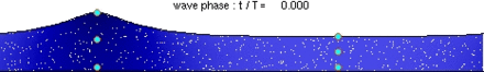
A tsunami (plural: tsunamis or tsunami; from Japanese: 津波, lit. "harbour wave"; English pronunciation: /suːˈnɑːmi/ soo-nah-mee or /tsuːˈnɑːmi/ tsoo-nah-mee) , also known as a seismic sea wave, is a series of water waves caused by the displacement of a large volume of a body of water, generally an ocean or a large lake. Earthquakes, volcanic eruptions and other underwater explosions (including detonations of underwater nuclear devices), landslides, glacier calvings, meteorite impacts and other disturbances above or below water all have the potential to generate a tsunami.
Tsunami waves do not resemble normal sea waves, because their wavelength is far longer. Rather than appearing as a breaking wave, a tsunami may instead initially resemble a rapidly rising tide, and for this reason they are often referred to as tidal waves. Tsunamis generally consist of a series of waves with periods ranging from minutes to hours, arriving in a so-called "wave train". Wave heights of tens of metres can be generated by large events. Although the impact of tsunamis is limited to coastal areas, their destructive power can be enormous and they can affect entire ocean basins; the 2004 Indian Ocean tsunami was among the deadliest and most published natural disasters in human history with at least 290,000 people, including tourists from all over the world killed or missing in 14 countries bordering the Indian Ocean. The 1908 Messina earthquake and tsunami took about 123,000 lives on in Sicily and Calabria, southern Italy but went much less in the public discussion. The difference in attention economy is generally not based on the amount of victims, but in the stability and status of the specific survivor population and its culture of remembrance of a certain disaster.
Etymology:
The term tsunami comes from the Japanese 津波, composed of the two kanji 津 (tsu) meaning "harbour" and 波 (nami), meaning "wave". (For the plural, one can either follow ordinary English practice and add an s, or use an invariable plural as in the Japanese.)
Tsunami are sometimes referred to as tidal waves, which are unusually high sea waves that are triggered especially by earthquakes. In recent years, this term has fallen out of favor, especially in the scientific community, because tsunami actually have nothing to do with tides. The once-popular term derives from their most common appearance, which is that of an extraordinarily high tidal bore. Tsunami and tides both produce waves of water that move inland, but in the case of tsunami the inland movement of water may be much greater, giving the impression of an incredibly high tide. Although the meanings of "tidal" include "resembling" or "having the form or character of" the tides, and the term tsunami is no more accurate because tsunami are not limited to harbours, use of the term tidal wave is discouraged by geologists and oceanographers.
Seismic sea wave:
The term seismic sea wave also is used to refer to the phenomenon, because the waves most often are generated by seismic activity such as earthquakes. Prior to the rise of the use of the term "tsunami" in English-speaking countries, scientists generally encouraged the use of the term "seismic sea wave" rather than the inaccurate term "tidal wave." However, like "tsunami," "seismic sea wave" is not a completely accurate term, as forces other than earthquakes – including underwater landslides, volcanic eruptions, land slumping into the ocean, meteorite impacts, or even the weather when the atmospheric pressure changes very rapidly – can generate such waves.
Source: www.youtube.com
Generation mechanisms:
Tsunami can be generated when the sea floor abruptly deforms and vertically displaces the overlying water. Tectonic earthquakes are a particular kind of earthquake that are associated with the Earth's crustal deformation; when these earthquakes occur beneath the sea, the water above the deformed area is displaced from its equilibrium position. More specifically, a tsunami can be generated when thrust faults associated with convergent or destructive plate boundaries move abruptly, resulting in water displacement, owing to the vertical component of movement involved. Movement on normal faults will also cause displacement of the seabed, but the size of the largest of such events is normally too small to give rise to a significant tsunami.
Tsunamis have a small amplitude (wave height) offshore, and a very long wavelength (often hundreds of kilometres long, whereas normal ocean waves have a wavelength of only 30 or 40 metres), which is why they generally pass unnoticed at sea, forming only a slight swell usually about 300 millimetres (12 in) above the normal sea surface. They grow in height when they reach shallower water, in a wave shoaling process described below. A tsunami can occur in any tidal state and even at low tide can still inundate coastal areas.
On April 1, 1946, a magnitude-7.8 (Richter Scale) earthquake occurred near the Aleutian Islands, Alaska. It generated a tsunami which inundated Hilo on the island of Hawai'i with a 14-metre high (46 ft) surge. The area where the earthquake occurred is where the Pacific Ocean floor is subducting (or being pushed downwards) under Alaska.
Examples of tsunami originating at locations away from convergent boundaries include Storegga about 8,000 years ago, Grand Banks 1929, Papua New Guinea 1998 (Tappin, 2001). The Grand Banks and Papua New Guinea tsunamis came from earthquakes which destabilised sediments, causing them to flow into the ocean and generate a tsunami. They dissipated before traveling transoceanic distances.
Landslides:
In the 1950s, it was discovered that larger tsunamis than had previously been believed possible could be caused by giant submarine landslides. These rapidly displace large water volumes, as energy transfers to the water at a rate faster than the water can absorb. Their existence was confirmed in 1958, when a giant landslide in Lituya Bay, Alaska, caused the highest wave ever recorded, which had a height of 524 metres (over 1700 feet). The wave didn't travel far, as it struck land almost immediately. Two people fishing in the bay were killed, but another boat amazingly managed to ride the wave.
Another landslide-tsunami event occurred in 1963 when a massive landslide from Monte Toc went into the Vajont Dam in Italy. The resulting wave overtopped the 262 m (860 ft) high dam by 250 metres (820 ft) and destroyed several towns. Around 2,000 people died. Scientists named these waves megatsunami. Scientists discovered that extremely large landslides from volcanic island collapses may be able to generate megatsunamis that can cross oceans.
Meteotsunamis:
Some meteorological conditions, especially deep depressions such as tropical cyclones, can generate a type of storm surge called a meteotsunami which raises water heights above normal levels, often suddenly at the shoreline. In the case of deep tropical cyclones, this is due to very low atmospheric pressure and inward swirling winds causing an uplifted dome of water to form under and travel in tandem with the storm. When these water domes reach shore, they rear up in shallows and surge laterally like earthquake-generated tsunamis, typically arriving shortly after landfall of the storm's eye.
Man-made tsunamis by nuclear bombs:
There has been considerable speculation on the possibility of using nuclear weapons to cause tsunamis near to an enemy coastline. Even during World War II consideration of the idea using conventional explosives was explored (see tsunami bomb).
Nuclear testing in the Pacific Proving Ground by the United States seemed to generate poor results. Operation Crossroads fired two 20 kilotonnes of TNT (84 TJ) bombs, one in the air and one underwater, above and below the shallow (50 m (160 ft)) waters of the Bikini Atoll lagoon. Fired about 6 km (3.7 mi) from the nearest island, the waves there were no higher than 3–4 m (9.8–13.1 ft) upon reaching the shoreline. Other underwater tests, mainly Hardtack I/Wahoo (deep water) and Hardtack I/Umbrella (shallow water) confirmed the results. Analysis of the effects of shallow and deep underwater explosions indicate that the energy of the explosions doesn't easily generate the kind of deep, all-ocean waveforms which are tsunamis; most of the energy creates steam, causes vertical fountains above the water, and creates compressional waveforms. Tsunamis are hallmarked by permanent large vertical displacements of very large volumes of water which don't occur in explosions.
Warnings and predictions:
Drawbacks can serve as a brief warning. People who observe drawback (many survivors report an accompanying sucking sound), can survive only if they immediately run for high ground or seek the upper floors of nearby buildings. In 2004, ten-year old Tilly Smith of Surrey, England, was on Maikhao beach in Phuket, Thailand with her parents and sister, and having learned about tsunamis recently in school, told her family that a tsunami might be imminent. Her parents warned others minutes before the wave arrived, saving dozens of lives. She credited her geography teacher, Andrew Kearney.
In the 2004 Indian Ocean tsunami drawback was not reported on the African coast or any other east-facing coasts that it reached. This was because the wave moved downwards on the eastern side of the fault line and upwards on the western side. The western pulse hit coastal Africa and other western areas.
A tsunami cannot be precisely predicted, even if the magnitude and location of an earthquake is known. Geologists, oceanographers, and seismologists analyse each earthquake and based on many factors may or may not issue a tsunami warning. However, there are some warning signs of an impending tsunami, and automated systems can provide warnings immediately after an earthquake in time to save lives. One of the most successful systems uses bottom pressure sensors, attached to buoys, which constantly monitor the pressure of the overlying water column.
Regions with a high tsunami risk typically use tsunami warning systems to warn the population before the wave reaches land. On the west coast of the United States, which is prone to Pacific Ocean tsunami, warning signs indicate evacuation routes. In Japan, the community is well-educated about earthquakes and tsunamis, and along the Japanese shorelines the tsunami warning signs are reminders of the natural hazards together with a network of warning sirens, typically at the top of the cliff of surroundings hills.
The Pacific Tsunami Warning System is based in Honolulu, Hawaiʻi. It monitors Pacific Ocean seismic activity. A sufficiently large earthquake magnitude and other information triggers a tsunami warning. While the subduction zones around the Pacific are seismically active, not all earthquakes generate tsunami. Computers assist in analysing the tsunami risk of every earthquake that occurs in the Pacific Ocean and the adjoining land masses.
External links:
http://simple.wikipedia.org/wiki/Tsunami
http://en.wikipedia.org/wiki/Natural_disaster
http://en.wikipedia.org/wiki/Tsunami_earthquake
http://en.wikipedia.org/wiki/Indian_Ocean_Tsunami_Warning_System